Easter Sunday I got home from church and saw the light blinking on the answering machine. That was quite unusual because most of the people who would be calling me, knew I would be at church, so I was anxious to hear the message.It was my cousin, R.P. He had been on Google Earth and had pictures of the Petterborg farm as it looks today!
Before I post the pictures, there needs to be a short explanation. Marie was born and raised on the island of Helgoya on a farm named Hovinsholm. According to Wikipedia, Helgoya is the largest fresh water island in Norway. It is connected to the peninsula known as Nes by a bridge since 1957. It was formerly a part of Nes municipality.
The island consists of 32 farms. The most notable of these are the old manor
Hovinsholm that until 1612 had its own church. Here is a
link to the article on Wikipedia and a small map that puts into perspective where Helgoya and Nes are located.
I am not sure how Ole and Marie met--was Ole on Helgoya or was Marie on the peninsula? I do know that Marie was born on Hovinsholm. The parish records for her birth, christening and marriage show her birth place. The parish records for Gine, Ole Johan and Anne Mathea's christenings also show Hovinsholm. I always thought that meant the three children were also born there, but the more I look at things, the more I think it was in reference to her birth place and not theirs.
Enough said--here are the pictures:
 |
| Image from Google Earth |
Above: The land at the bottom of the picture is the peninsula. The picture is looking south onto Helgoya. Hovinsholm is at the far tip of the island.
Below: is a picture of the Hovinsholm farm. Pretend the red line is an arrow pointing down at the farm. I don't know how to make a real arrow and have it transfer to blogspot!
 |
| Image from Google Earth |
Below: A picture of the area in the winter time. This is gorgeous!!! It looks like a Christmas card.
 |
| Image from Google Earth |
Below: You can see the bride connecting the two pieces of land--Helgoya to Nes. Helgoya is at the top.
 |
| Image from Google Earth |
Below: Here is another picture of the bridge. The land on the left is Nes and Helgoya is on the right but is not showing. Notice the church on the tip by the head of the bridge.
 |
| Image from Google Earth |
|
Below: Here is a closer look at the church at the head of the bridge.
 |
| Image from Google Earth |
Below: Here is the chapel in the wintertime:
 |
| Image from Google Earth |
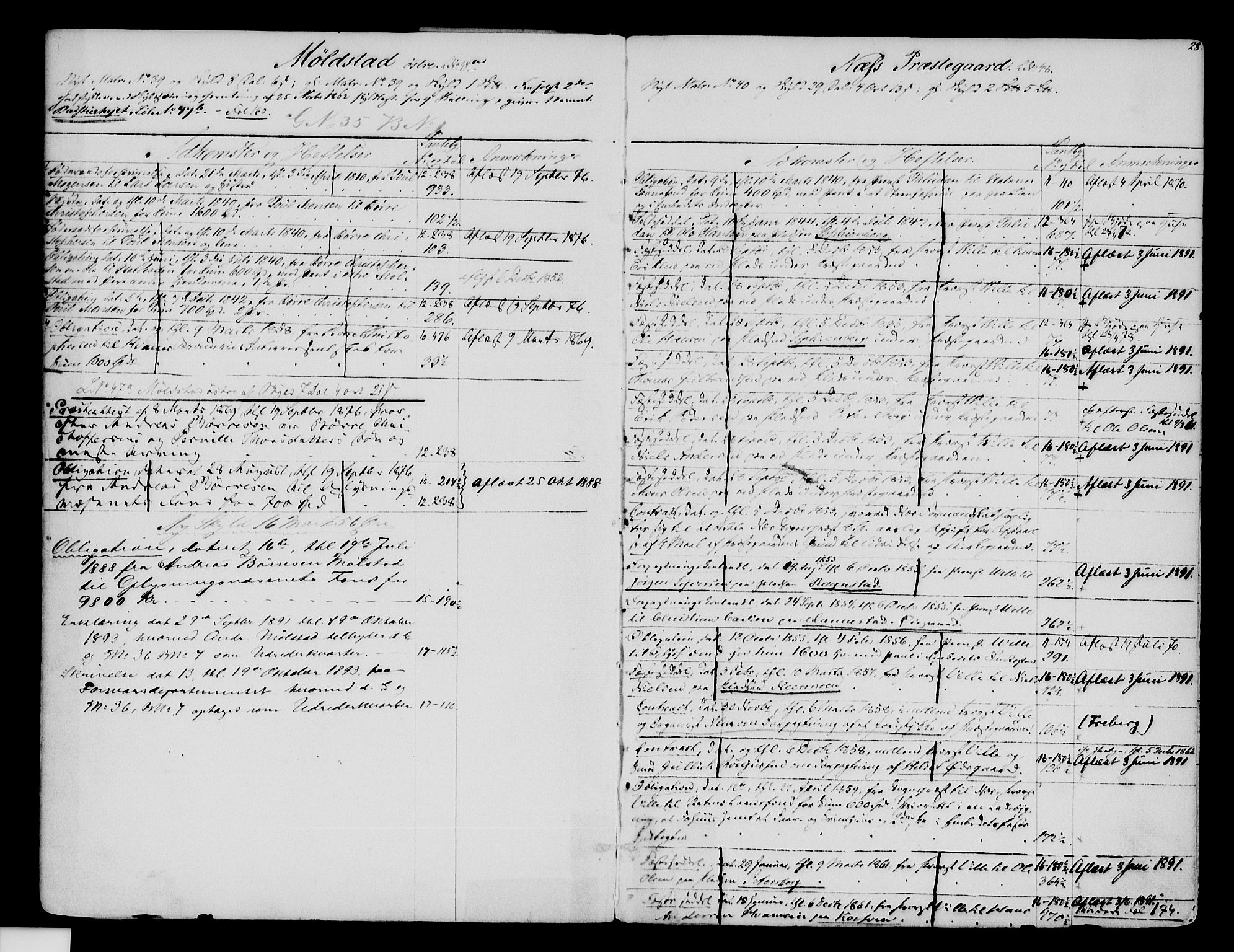
I am not sure when the family moved to the area of Nes known as the Petterborg farm. Here is an
earlier post about the books that give the history of the farms. It does not tell when they took over the farm.
Below: The picture sent by R.P.of the farm. The red line at the top of the picture is just above 3 buildings. This is where R.P. has figured out the farm in located. The red line at the bottom is pointing to the church that is shown in the 2 pictures above.
 |
| Image from Google Earth. |
I am sorry these pictures are so small. If you would like bigger pictures, just double click on the image and it brings up a much larger image. When you are finished with the larger image, there is a white X in the right corner of the image. Click on that and the image closes and you will be back on the blog.
If you want to save a copy of the image, right click on the larger image, a menu will pop up. Choose the choice that says something like "Save image as" (depending on the browser you are using, the wording may be a little different). Give the image a name and choose where you want to save it on your computer.
Below: A closer up view of the farm. This is from the side so that you can see more.
 |
| Image from Google Earth. |
Thanks to R.P. for finding these modern day pictures.
In an
earlier post I showed the farm as it was in 1988 when L.P. was able to visit in person.
I hope someday, I too, can visit the farm.


