Family Group Sheet
Showing posts with label Petterborg Farm. Show all posts

Thursday, May 12, 2011

New Information on the Petterborg Farm

It happened again--a cousin, reading the blog, shared new information about the Petterborg farm. The cousin is R.S. She speaks Norwegian, works part of the year as a consultant on the International floor at the Family History Library in Salt Lake City and has really helped me in the past.
Thank you, again, R.S. for sharing your expertise.

I wrote here about not being able to find when Ole and Maria moved onto the Petterborg farm. R.S. sent an email with the information. Here is what she said:
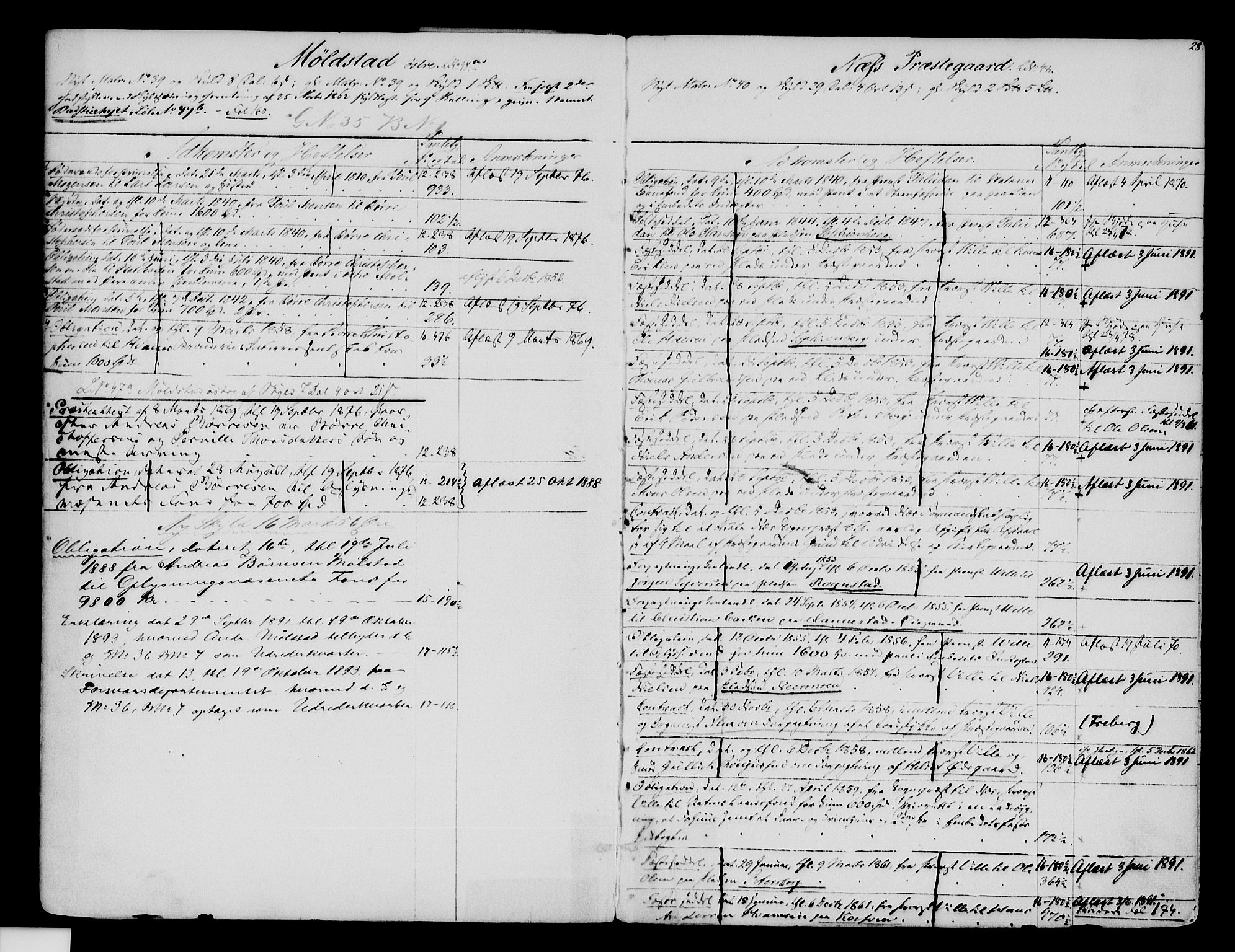
Here(below on this blog) are two images from tinglysingsdokumenter (the court documents). The first is from the register or Mortgage book index, the second is from the Mortgage book. This gives the date Ole Olsen leased the part of Prestegarden which was called Petterborg. They were dated the 29 January 1861 and read in court the 9 March 1861.
From The National Archives of Norway website
Above: Image of the Mortgage Book Index. Since this image is so small you can see the original image here. It is on the right hand page, the next to the bottom entry.

Below: Image of the Mortgage Book document. The original can be seen here.  It is #10 on page 181.
          The document translates as: Lease document dated 29  January, court  dated 9 March 1861, from Priest Wille to Ole Olsen at (on) the place,  Petersborg. (That is the way it is spelled there).

From The National Archives of Norway website


Tuesday, May 3, 2011

Google Earth

Easter Sunday I got home from church and saw the light blinking on the answering machine. That was quite unusual because most of the people who would be calling me, knew I would be at church, so I was anxious to hear the message.It was my cousin, R.P. He had been on Google Earth and had pictures of the Petterborg farm as it looks today!

Before I post the pictures, there needs to be a short explanation. Marie was born and raised on the island of Helgoya on a farm named Hovinsholm. According to Wikipedia,  Helgoya is the largest fresh water island in Norway. It is connected to the peninsula known as Nes by a bridge since 1957. It was formerly a part of Nes municipality.
The island consists of 32 farms. The most notable of these are the old manor Hovinsholm that until 1612 had its own church. Here is a link to the article on Wikipedia and a small map that puts into perspective where Helgoya and Nes are located.

I am not sure how Ole and Marie met--was Ole on Helgoya or was Marie on the peninsula? I do know that Marie was born on Hovinsholm. The parish records for her birth, christening and marriage show her birth place. The parish records for Gine, Ole Johan and Anne Mathea's christenings also show Hovinsholm. I always thought that meant the three children were also born there, but the more I look at things, the more I think it was in reference to her birth place and not theirs.

Enough said--here are the pictures:

Image from Google Earth
Above: The land at the bottom of the picture is the peninsula. The picture is looking south onto Helgoya. Hovinsholm is at the far tip of the island.

Below: is a picture of the Hovinsholm farm. Pretend the red line is an arrow pointing down at the farm. I don't know how to make a real arrow and have it transfer to blogspot!

Image from Google Earth
Below: A picture of the area in the winter time. This is gorgeous!!! It looks like a Christmas card.

Image from Google Earth
Below: You can see the bride connecting the two pieces of land--Helgoya to Nes. Helgoya is at the top.

Image from Google Earth
Below: Here is another picture of the bridge. The land on the left is Nes and Helgoya is on the right but is not showing. Notice the church on the tip by the head of the bridge.

Image from Google Earth
Below: Here is a closer look at the church at the head of the bridge.

Image from Google Earth
Below: Here is the chapel in the wintertime:

Image from Google Earth
I am not sure when the family moved to the area of Nes known as the Petterborg farm. Here is an earlier post about the books that give the history of the farms. It does not tell when they took over the farm.

Below: The picture sent by R.P.of the farm. The red line at the top of the picture is just above 3 buildings. This is where R.P. has figured out the farm in located. The red line at the bottom is pointing to the church that is shown in the 2 pictures above.
Image from Google Earth.
I am sorry these pictures are so small. If you would like bigger pictures, just double click on the image and it brings up a much larger image. When you are finished with the larger image, there is a white X in the right corner of the image. Click on that and the image closes and you will be back on the blog.
If you want to save a copy of the image, right click on the larger image, a menu will pop up. Choose the choice that says something like "Save image as" (depending on the browser you are using, the wording may be a little different). Give the image a name and choose where you want to save it on your computer.

Below: A closer up view of the farm. This is from the side so that you can see more.
Image from Google Earth.
Thanks to R.P. for finding these modern day pictures.
In an earlier post I showed the farm as it was in 1988 when L.P. was able to visit in person.
I hope someday, I too, can visit the farm.

Monday, April 18, 2011

Added information to today's earlier post

I posted photos earlier today and I received an email from L.P. He is the person who furnished the photos. He sent some added information about the family and area.
Here is what he sent--

 We were there in 1988. Nes (which means headland or promontory) is a common name in Norway, there may be a Nes in every county. Our Nes is in Hedmarken as you know. You can see it if you go to Google maps and find Hamar (north of Oslo) and then look to the west. At the tip of the peninsula into lake Mjsoa, you should find it. Petterborg is a place name; the name of a farm. The original settler (no relation) was named Petter and this was his borg (castle). Our name was taken from the site, not any person. The people that lived at the farm when we visited in 88 were named Stollen (the other name of the mailbox). If you look south from Nes, you will see an island, Helgoya, connected by a bridge. Our family lived on a farm at the southern tip of that island prior to moving to Petterborg. 
The name should be pronounced Petter Borg, not Peter Berg the way I grew up.

I have received some aerial photos of the area from R.P. but I was waiting to post them until I have a source. They are a great view of the area. Look for a post in the near future.

Modern Day Nes, Norway & the Petterborg Farm

When cousin, R.P., learned about the blog he sent me some beautiful photographs that he had received several years ago from another cousin, L.P. I contacted L.P. and he gave his permission to post the pictures.
In case this is the first post that you have read, I do not give the full names of living individuals. I will be more than happy to share contact information if you contact me personally.

They say a picture is worth a thousand words and I think these prove it.
This is a view of modern Nes, Norway.

Picture provided by and used with permission from L.P.

Just a little wider view.

Picture provided by and used with permission from L.P.

The Petterborg farm. I am not sure if all of these buildings are part of the farm but I assume since they are so close together that they are. They also look newer than buildings that would have been there in the 1860's when Ole and Marie lived there.
Picture provided by and used with permission from L.P.


Not much different than the bank of mailboxes found in rural America!

Picture provided by and used with permission from L.P.

Oh, to see this in person! Maybe, someday.

Picture provided by and used with permission from L.P.